
GPS-Genauigkeit erklärt: Was Geocacher wissen müssen
GPS-Genauigkeit bezeichnet die Präzision, mit der ein GPS-Empfänger deinen aktuellen Standort bestimmen kann. Für zivile Nutzer liegt sie unter freiem Himmel typischerweise zwischen 3 und 10 Metern. Korrektursysteme wie SBAS, EGNOS und DGPS können diesen Wert auf unter 5 Meter drücken. Für Geocacher ist das keine abstrakte Technikfrage. Wer versteht, warum sein Gerät manchmal 8 Meter daneben liegt und manchmal auf den Zentimeter stimmt, sucht deutlich erfolgreicher und legt bessere Caches an. Diese Erklärung der GPS-Genauigkeit gibt dir das Wissen dafür.
Wie funktioniert GPS zur Standortbestimmung?
GPS steht für Global Positioning System und ist ein satellitengestütztes Navigationssystem der USA. Es besteht aus mindestens 24 aktiven Satelliten, die in rund 20.200 Kilometern Höhe die Erde umkreisen. Jeder Satellit sendet ständig ein Signal mit seiner genauen Position und der aktuellen Atomzeit.
Dein Empfänger misst, wie lange das Signal von jedem Satelliten bis zu ihm braucht. Aus dieser Laufzeit errechnet er die Entfernung zum Satelliten. Mindestens vier Satelliten sind nötig, um eine dreidimensionale Position zu berechnen. Drei davon liefern Längen- und Breitengrad sowie Höhe, der vierte korrigiert den Uhrzeitfehler im Empfänger.
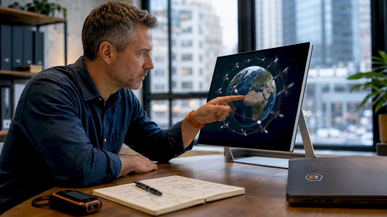
Das Verfahren heißt Trilateration. Stell dir Kugeln vor, die sich um jeden Satelliten spannen. Wo sich alle vier Kugeln schneiden, bist du. Das klingt einfach, ist aber auf Millisekunden genaue Physik.
Moderne Geräte nutzen nicht nur GPS allein. Multi-GNSS-Empfänger verarbeiten gleichzeitig Signale von GPS (USA), Galileo (Europa), GLONASS (Russland) und BeiDou (China). Das erhöht die Zahl der verfügbaren Satelliten erheblich. Besonders in Wäldern, Schluchten oder Städten macht das einen spürbaren Unterschied.
Die vier Schritte der Standortbestimmung im Überblick:
- Satellit sendet Position und Atomzeit aus
- Empfänger misst Signallaufzeit zu mindestens vier Satelliten
- Trilateration berechnet dreidimensionale Position
- Korrekturdienste verfeinern das Ergebnis optional
Welche Faktoren beeinflussen die GPS-Genauigkeit?
Die GPS-Genauigkeit ist kein fixer Wert. Sie schwankt je nach Umgebung, Gerät und Tageszeit. Wer das versteht, interpretiert sein Gerät viel besser.
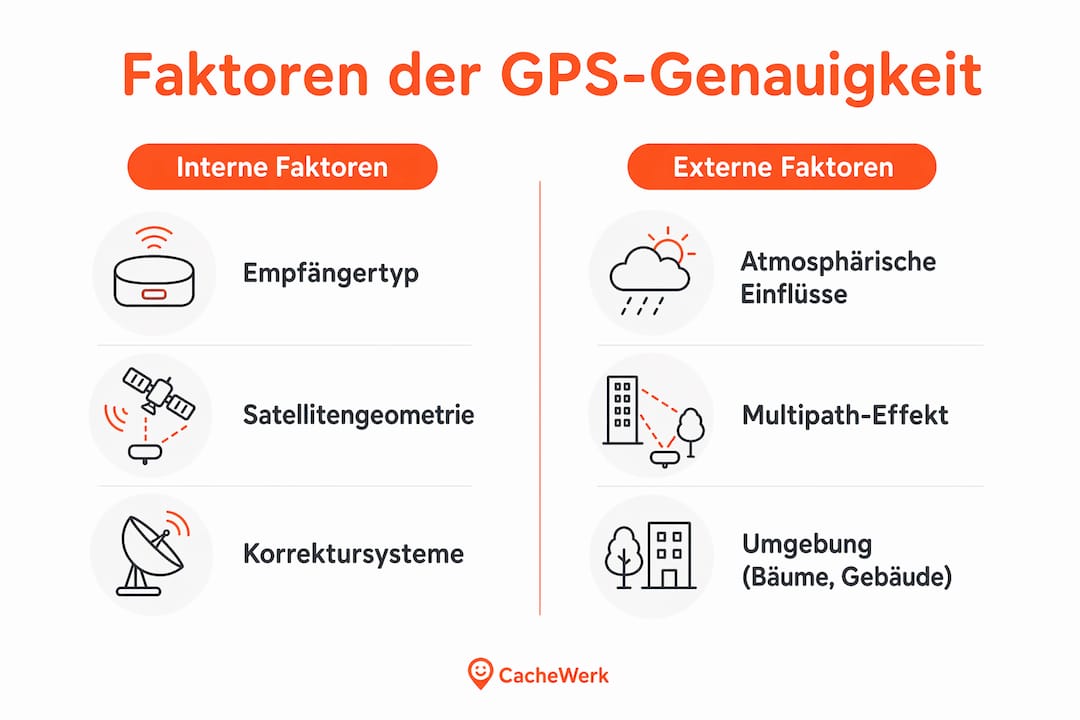
Satellitengeometrie und DOP-Wert
Der DOP-Wert (Dilution of Precision) beschreibt, wie die räumliche Verteilung der sichtbaren Satelliten die Genauigkeit beeinflusst. Stehen alle Satelliten eng beieinander am Himmel, ist der DOP-Wert hoch und die Genauigkeit schlecht. Sind sie weit verteilt, sinkt der DOP-Wert und die Position wird zuverlässiger. Ein DOP-Wert unter 2 gilt als gut, über 5 wird es problematisch.
Atmosphärische Einflüsse
Das GPS-Signal durchquert Ionosphäre und Troposphäre. Beide Schichten verlangsamen das Signal leicht und verfälschen die Laufzeitmessung. Atmosphärische Effekte können Positionen um über 100 Meter verfälschen, wenn keine Korrektur erfolgt. Korrektursysteme wie EGNOS gleichen genau diese Fehler aus.
Multipath-Effekt
Der Multipath-Effekt ist eine unterschätzte Fehlerquelle. GPS-Signale prallen an Gebäuden, Felswänden oder dichten Baumkronen ab und erreichen den Empfänger auf Umwegen. Reflektierte Signale führen zu Verzerrungen von mehreren Metern, selbst wenn genug Satelliten sichtbar sind. Profis stellen sich deshalb leicht abseits von Hindernissen, bevor sie eine Position speichern.
Umgebungsbedingungen
- Dichter Wald: Baumkronen absorbieren und streuen das Signal, die Genauigkeit sinkt auf 5–15 Meter
- Städtische Schluchten: Hochhäuser blockieren Satelliten und erzeugen starke Multipath-Effekte
- Täler und Schluchten: Wenige Satelliten sichtbar, schlechter DOP-Wert
- Tunnel und Gebäude: Kein GPS-Empfang möglich
- Freies Gelände: Beste Bedingungen, typisch 3–5 Meter Genauigkeit
Hardwarequalität
Die Qualität des Empfängers spielt eine direkte Rolle. Multi-GNSS-Empfänger mit Unterstützung für GPS, Galileo, GLONASS und BeiDou liefern zuverlässigere Koordinaten als reine GPS-Geräte. Auch der Antennentyp beeinflusst, wie gut schwache Signale empfangen werden.
Profi-Tipp: Halte dein Gerät beim Geocaching waagerecht und mit freier Sicht zum Himmel. Schon eine leichte Neigung oder das Abdecken der Antenne mit der Hand kann die Genauigkeit um mehrere Meter verschlechtern.
Welche Korrektursysteme verbessern die GPS-Genauigkeit?
Korrektursysteme sind der schnellste Weg, aus einer 10-Meter-Schätzung eine 1-Meter-Position zu machen. Für Geocacher und Outdoor-Fans sind vor allem SBAS und DGPS relevant.
SBAS und EGNOS
SBAS steht für Satellite-Based Augmentation System. Es ist ein Netz von Bodenstationen, das GPS-Fehler misst und Korrekturdaten per Satellit an Empfänger sendet. In Europa heißt das System EGNOS (European Geostationary Navigation Overlay Service). SBAS/EGNOS verbessert die Genauigkeit auf 1–3 Meter. Das ist für die meisten Geocacher mehr als ausreichend. EGNOS ist kostenlos und auf jedem modernen Empfänger aktivierbar.
DGPS
DGPS steht für Differenzielles GPS. Dabei empfängt dein Gerät Korrekturdaten von einer bekannten Referenzstation in der Nähe. DGPS erreicht eine Genauigkeit von 0,5–5 Metern. Die Qualität hängt davon ab, wie nah die Referenzstation ist. Je näher, desto besser.
RTK-GNSS
RTK steht für Real Time Kinematic. Dieses Verfahren nutzt die Trägerwelle des GPS-Signals statt nur der Laufzeit. Das Ergebnis ist Zentimetergenauigkeit in Echtzeit. RTK-GNSS ist vor allem in der Vermessung und Landwirtschaft im Einsatz. Für normale Geocacher ist es technisch und finanziell überdimensioniert, aber interessant zu wissen.
| Korrektursystem | Erreichbare Genauigkeit | Typische Anwendung |
|---|---|---|
| Standard-GPS | 3–10 Meter | Allgemeine Navigation |
| SBAS / EGNOS | 1–3 Meter | Outdoor, Geocaching, Drohnen |
| DGPS | 0,5–5 Meter | Vermessung, Schifffahrt |
| RTK-GNSS | Zentimeterbereich | Professionelle Vermessung |
Profi-Tipp: Aktiviere EGNOS in den Einstellungen deines GPS-Geräts oder deiner App. Die Funktion heißt je nach Gerät “SBAS”, “EGNOS” oder “Korrekturdienst”. Sie ist kostenlos und verbessert die Genauigkeit sofort spürbar.
Wie kannst du die GPS-Genauigkeit beim Geocaching verbessern?
Gute GPS-Genauigkeit entsteht nicht nur durch das Gerät. Dein Verhalten im Gelände macht einen großen Teil aus. Diese Maßnahmen helfen direkt:
- Multi-GNSS aktivieren: Stelle sicher, dass dein Gerät alle verfügbaren Satellitensysteme nutzt. Die Kombination von GPS, Galileo, GLONASS und BeiDou verbessert die Signalverfügbarkeit besonders in schwierigem Gelände deutlich.
- Freie Sicht zum Himmel suchen: Bewege dich aus dem Schatten von Gebäuden oder Baumkronen heraus, bevor du eine Position speicherst oder suchst. Schon zwei Meter Abstand von einer Hauswand können den Unterschied machen.
- Warten, bis das Signal stabil ist: Viele Geräte zeigen nach dem Einschalten zunächst eine ungenaue Position. Warte 30–60 Sekunden, bis sich die angezeigte Genauigkeit stabilisiert hat.
- EGNOS oder SBAS aktivieren: Korrekturdienste ermöglichen den Sprung von grober 10-Meter-Orientierung zu präziser 1-3-Meter-Lokalisierung. Die Aktivierung dauert wenige Sekunden.
- Störquellen meiden: Tunnel, Tiefgaragen und enge Häuserschluchten blockieren das Signal vollständig. Warte mit der Suche, bis du wieder freies Gelände hast.
- Firmware aktuell halten: Aktuelle Firmware-Updates und richtige Geräteeinstellungen verbessern die Genauigkeit messbar. Hersteller veröffentlichen regelmäßig Updates, die Empfangsalgorithmen verbessern.
- Gerät kalibrieren: Manche Geräte bieten eine Kompasskalibrierung an. Eine kalibrierte Ausrichtung hilft, die angezeigte Richtung mit der tatsächlichen GPS-Position zu synchronisieren.
Wer GPS beim Geocaching gezielt einsetzt, kombiniert diese technischen Maßnahmen mit Erfahrung im Gelände. Ein gutes Gerät allein reicht nicht. Die Kombination aus richtiger Einstellung, freier Sicht und Geduld beim Einlesen macht den Unterschied zwischen “ungefähr hier” und “genau da”.
Wichtige Erkenntnisse
Die GPS-Genauigkeit liegt für zivile Nutzer typischerweise zwischen 3 und 10 Metern, lässt sich aber durch EGNOS, Multi-GNSS und richtiges Verhalten im Gelände auf 1–3 Meter verbessern.
| Thema | Details |
|---|---|
| Zivile GPS-Genauigkeit | Unter freiem Himmel typisch 3–10 Meter, mit EGNOS auf 1–3 Meter verbesserbar. |
| DOP-Wert beachten | Schlechte Satellitenverteilung verschlechtert die Genauigkeit erheblich, freie Sicht hilft. |
| Multipath-Effekt vermeiden | Abstand von Gebäuden und Wänden reduziert Signalreflexionen und Positionsfehler. |
| Multi-GNSS aktivieren | Galileo, GLONASS und BeiDou zusätzlich zu GPS erhöhen Zuverlässigkeit in schwierigem Gelände. |
| Firmware und Einstellungen | Aktuelle Software und aktiviertes EGNOS sind einfache Maßnahmen mit direktem Effekt. |
Was ich nach Jahren im Gelände wirklich über GPS-Genauigkeit denke
Ich erinnere mich gut an eine Suche in einem dichten Fichtenwald in Bayern. Mein Gerät zeigte 4 Meter Genauigkeit an, aber die angezeigte Position sprang ständig zwischen zwei Punkten hin und her, die gut 8 Meter auseinanderlagen. Das war kein Gerätefehler. Das war der Wald.
Was mich damals überrascht hat: Die angezeigte Genauigkeit auf dem Display ist oft optimistischer als die Realität. Das Gerät zeigt, was es rechnerisch schätzt. Der Multipath-Effekt und ein schlechter DOP-Wert tauchen dort nicht auf. Du siehst “3 Meter” und glaubst, du stehst auf dem Punkt. Tust du aber nicht.
Meine ehrliche Einschätzung: GPS ist ein Werkzeug, kein Orakel. Wer erwartet, dass ihn das Gerät auf den Zentimeter führt, wird frustriert. Wer versteht, dass 5 Meter Abweichung bei schlechten Bedingungen völlig normal sind, sucht entspannter und findet trotzdem. Ich kombiniere GPS immer mit Kartenkenntnis und Geländebeobachtung. Das Gerät bringt mich in die Nähe. Den Rest macht der Blick auf die Umgebung.
Besonders bei selbst gelegten Caches rate ich dazu, die Koordinaten mehrfach und zu verschiedenen Tageszeiten zu messen. Dann den Mittelwert zu nehmen. Eine einzige Messung unter Bäumen kann leicht 10 Meter daneben liegen. Drei Messungen an verschiedenen Tagen geben dir ein viel realistischeres Bild.
GPS-Genauigkeit zu verstehen bedeutet auch, gelassener mit Abweichungen umzugehen. Ein Cache, der laut Koordinaten “hier” liegt, aber erst nach kurzem Suchen im Umkreis von 5 Metern gefunden wird, ist kein schlechter Cache. Das ist GPS in der Praxis.
— Benedikt
Gut versteckt, präzise gefunden: Caches von Cachewerk
Wer die GPS-Genauigkeit versteht, legt auch bessere Caches an. Denn ein gutes Versteck braucht nicht nur clevere Tarnung, sondern auch eine verlässliche Position, die Finder wirklich ans Ziel bringt.
Bei Cachewerk findest du Verstecke, die genau dafür gemacht sind. Die Geocaching Ammo-Box Trick Edition ist wetterfest, täuschend echt und für alle Geländetypen geeignet. Egal ob Wald, Stadtpark oder offenes Gelände. Wer seinen Cache mit präzisen Koordinaten und einem durchdachten Versteck kombiniert, sorgt für ein Erlebnis, das Finder wirklich begeistert. Schau dich bei Cachewerk um und finde das passende Versteck für dein nächstes Abenteuer.
FAQ
Wie genau ist ziviles GPS normalerweise?
Ziviles GPS erreicht unter freiem Himmel typischerweise 3–10 Meter Genauigkeit. Mit aktiviertem EGNOS verbessert sich dieser Wert auf 1–3 Meter.
Was ist der DOP-Wert beim GPS?
Der DOP-Wert (Dilution of Precision) beschreibt, wie gut die sichtbaren Satelliten am Himmel verteilt sind. Ein niedriger DOP-Wert bedeutet bessere Genauigkeit, ein hoher Wert schlechtere.
Warum springt meine GPS-Position ständig?
Springende Positionen entstehen meist durch den Multipath-Effekt, bei dem Signale an Gebäuden oder Bäumen reflektiert werden. Bewege dich in freies Gelände und warte, bis sich die Position stabilisiert hat.
Was ist EGNOS und wie aktiviere ich es?
EGNOS ist das europäische Korrektursystem für GPS und verbessert die Genauigkeit auf 1–3 Meter. Du aktivierst es in den Einstellungen deines Geräts unter “SBAS” oder “Korrekturdienst”, die Nutzung ist kostenlos.
Lohnt sich ein Multi-GNSS-Gerät für Geocaching?
Ja. Multi-GNSS-Geräte mit GPS, Galileo, GLONASS und BeiDou liefern besonders in Wäldern und städtischen Umgebungen deutlich zuverlässigere Koordinaten als reine GPS-Empfänger.