
Was sind Geocaching Waypoints? Erklärung für Einsteiger
Geocaching Waypoints sind zusätzliche GPS-Koordinaten, die ein Cache-Owner im System hinterlegt, um Stationen, Parkplätze oder wichtige Hinweise auf der Schatzsuche zu markieren. Sie gehen über den eigentlichen Cache-Standort hinaus und werden in Apps sowie auf Cache-Seiten oft als „WP" abgekürzt. Wer wissen möchte, was sind Geocaching Waypoints, bekommt hier eine klare Antwort: Sie strukturieren die Suche, zeigen den Weg durch mehrstufige Caches und liefern Informationen, die das GPS allein nicht geben kann. Besonders bei Multi-Caches sind sie unverzichtbar.
Welche Arten von Waypoints gibt es beim Geocaching?
Geocaching-Waypoints sind zusätzliche Koordinaten, die der Cache-Owner über die Funktion „Additional Waypoints" im System einträgt. Jeder Waypoint hat einen Typ, der seinen Zweck beschreibt. Das macht die Suche deutlich übersichtlicher.
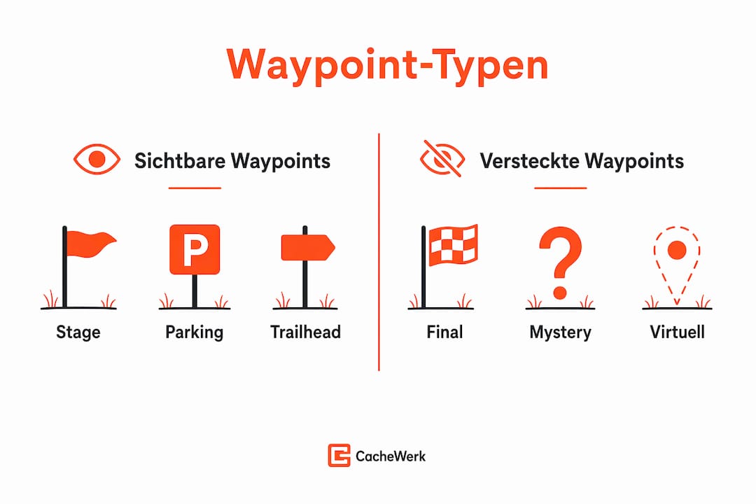
Die wichtigsten Waypoint-Typen im Überblick:
- Final (Abkürzung: F): Der eigentliche Fundort des Caches. Bei Multi-Caches ist das die letzte Station, an der die Dose liegt.
- Parking (Abkürzung: PK): Ein empfohlener Parkplatz in der Nähe des Caches. Kein Pflichtpunkt, aber sehr praktisch für die Anreise.
- Stage (Abkürzung: S): Eine Zwischenstation bei Multi-Caches. Hier findest du Koordinaten oder Hinweise für die nächste Station.
- Trailhead (Abkürzung: TH): Der Startpunkt eines Wanderwegs oder Pfads zum Cache. Besonders bei Caches im Gelände hilfreich.
- Question to Answer (Abkürzung: Q): Ein Punkt, an dem du eine Frage beantworten oder eine Aufgabe lösen musst, um weiterzukommen.
- Reference Point (Abkürzung: RP): Ein allgemeiner Orientierungspunkt ohne spezifische Aufgabe, zum Beispiel ein markantes Gebäude oder Denkmal.
Waypoints lassen sich außerdem in sichtbare und versteckte unterteilen. Sichtbare Waypoints zeigt die App direkt auf der Karte an. Versteckte Waypoints, etwa der finale Fundort bei einem Mystery-Cache, werden erst nach dem Lösen eines Rätsels freigeschaltet oder müssen manuell eingetragen werden. Nicht korrekt eingetragene Waypoints erschweren die Suche unnötig, weil sie in vielen Apps schlicht unsichtbar bleiben.
Profi-Tipp: Schau dir vor jeder Tour die Waypoint-Typen in der Cache-Beschreibung genau an. Ein „PK"-Waypoint spart dir oft zehn Minuten Parkplatzsuche.
Wie nutzt man Waypoints praktisch bei der Schatzsuche?
Waypoints anzuwenden ist einfacher als viele Einsteiger denken. Der Zugriff auf Waypoints erfolgt in Geocaching-Apps direkt auf der Cache-Seite unter dem Bereich „Navigation" oder „Wegpunkte". Dort siehst du alle vom Owner eingetragenen Koordinaten auf einen Blick.
So gehst du Schritt für Schritt vor:
- Cache auswählen und Waypoints prüfen. Öffne die Cache-Seite in deiner App und scrolle zu den Waypoints. Prüfe, welche Typen vorhanden sind und ob alle Koordinaten sichtbar sind.
- GPX-Datei importieren. Viele Geocacher laden GPX-Dateien herunter, die alle Waypoints eines Caches enthalten. Diese lassen sich direkt in GPS-Geräte oder Planungstools importieren.
- Navigation starten. Wähle den ersten relevanten Waypoint als Ziel. Bei einem Multi-Cache ist das meist die erste Stage. Nach dem Lösen der Aufgabe trägst du die neuen Koordinaten manuell ein oder sie erscheinen automatisch.
- Eigene Notizen ergänzen. Eigene virtuelle Waypoints anlegen hilft bei komplexen Mystery- oder Multi-Caches. Du kannst berechnete Koordinaten, Lösungswörter oder Skizzen direkt am Waypoint speichern.
Profi-Tipp: Nutze ein Planungstool wie GeoRoutePlanner, um mehrere Caches mit ihren Waypoints auf einer Karte zu sehen und die optimale Reihenfolge für deinen Ausflug zu planen. Das spart Zeit und Wege.
Für einen vollständigen Schritt-für-Schritt-Workflow beim Geocaching, der auch den Umgang mit Waypoints erklärt, lohnt sich ein Blick in den Cachewerk-Blog. Dort findest du praktische Abläufe für jede Erfahrungsstufe.

Welche Rolle spielen Waypoints bei Multi-Caches?
Multi-Caches sind die Cache-Gattung, bei der Waypoints ihre volle Stärke zeigen. Ein Multi-Cache besteht aus mindestens zwei physischen Stationen. Jede Station liefert Informationen oder Koordinaten für die nächste. Waypoints strukturieren diese Kette und machen sie für alle Beteiligten nachvollziehbar.
| Waypoint-Typ | Funktion im Multi-Cache | Sichtbarkeit |
|---|---|---|
| Stage | Zwischenstation mit Hinweisen | Sichtbar |
| Final | Fundort der Dose | Oft versteckt |
| Parking | Empfohlener Parkplatz | Sichtbar |
| Trailhead | Startpunkt des Wegs | Sichtbar |
| Question to Answer | Aufgabe oder Rätsel | Sichtbar |
Waypoints helfen bei Multi-Caches, die sogenannte 0,1-Meilen-Regel einzuhalten. Diese Regel besagt, dass physische Stationen eines Caches mindestens 0,1 Meilen voneinander entfernt sein müssen. Korrekt angelegte Waypoints zeigen dem Reviewer auf einen Blick, dass alle Abstände stimmen. Das beschleunigt den Freigabeprozess erheblich.
Für Cache-Owner hat das noch einen weiteren Vorteil. Korrekt aufgebaute Wegpunkte machen den eigenen Cache für andere Geocacher deutlich attraktiver, weil die Navigation klar und fehlerfrei ist. Ein schlecht strukturierter Multi-Cache mit fehlenden Waypoints führt schnell zu negativen Logs und Frust auf beiden Seiten.
Wer seinen eigenen Cache mit einer echten Waypoint-Station ausstatten möchte, findet bei Cachewerk das passende Vermessungspunkt-Versteck, ein 3D-gedrucktes Gehäuse aus PETG mit PETling und Bodenhülse, das sich unauffällig in jede Umgebung einfügt.
Welche Tipps sollten Geocaching-Anfänger bei Waypoints beachten?
Einsteiger machen beim Thema Waypoints oft denselben Fehler: Sie starten direkt mit einem komplexen Multi-Cache und wundern sich, warum die Suche nicht klappt. Experten empfehlen, mit einfachen Caches der Schwierigkeitsstufe D1 oder D2 zu beginnen, um den Umgang mit Waypoints entspannt zu erlernen. Das gibt dir Zeit, die Logik hinter den Wegpunkten zu verstehen, bevor du dich an Caches mit fünf oder mehr Stationen wagst.
Häufige Anfängerfehler und wie du sie vermeidest:
- GPS blind vertrauen. Das GPS zeigt dir die Koordinaten, aber nicht den Kontext. Waypoints sind oft die entscheidenden Hinweise, die das GPS allein nicht liefert. Lies immer die Cache-Beschreibung vollständig.
- Waypoint-Details überspringen. Manche Owner verstecken wichtige Hinweise im Beschreibungstext direkt beim Waypoint. Wer nur die Koordinaten abläuft, verpasst das.
- Zu viele Caches auf einmal planen. Für Anfänger werden 3–5 Funde pro Ausflug empfohlen, um Überforderung zu vermeiden. Das gilt besonders bei Multi-Caches mit mehreren Waypoints.
- Eigene Notizen vergessen. Trag berechnete Koordinaten sofort in die App ein. Wer auf sein Gedächtnis vertraut, verliert bei komplexen Rätseln schnell den Überblick.
Profi-Tipp: Lege vor dem Start eines Mystery-Caches einen eigenen virtuellen Waypoint mit deinen berechneten Finalkoordinaten an. So navigierst du direkt zum Ziel, ohne die Rechnung unterwegs wiederholen zu müssen.
Für die Tourenplanung lohnt sich außerdem ein Blick auf Outdoor-Komfort-Tipps, besonders wenn du längere Touren mit vielen Stationen planst. Pausen und die richtige Ausrüstung machen den Unterschied zwischen Spaß und Erschöpfung.
Wer ganz neu ins Geocaching einsteigt, ist mit einem Geocaching-Starter-Bundle von Cachewerk gut beraten. Das Bundle enthält PETling, Logbuch und Halterung, also alles, was du für deine ersten eigenen Caches oder die Schatzsuche brauchst.
Wichtige Erkenntnisse
Geocaching Waypoints sind der Schlüssel zu strukturierten Schatzsuchen, weil sie Navigation, Abstandsregeln und Cache-Aufbau in einem System vereinen.
| Thema | Details |
|---|---|
| Definition von Waypoints | Waypoints sind zusätzliche GPS-Koordinaten, die Stationen, Parkplätze oder Hinweise markieren. |
| Wichtigste Waypoint-Typen | Final, Stage, Parking, Trailhead und Question to Answer decken die häufigsten Anwendungsfälle ab. |
| Nutzung in Apps | Waypoints sind in der App unter „Navigation" sichtbar oder per GPX-Import verfügbar. |
| Bedeutung für Multi-Caches | Waypoints strukturieren mehrstufige Routen und helfen, die 0,1-Meilen-Regel einzuhalten. |
| Tipp für Einsteiger | Mit D1- oder D2-Caches starten und eigene Notizen direkt am Waypoint speichern. |
Waypoints aus der Praxis: Was ich Einsteigern wirklich mitgeben möchte
Ich erinnere mich noch gut an meinen ersten Multi-Cache. Drei Stationen, alle Waypoints sichtbar in der App, und trotzdem bin ich an der zweiten Station gescheitert. Der Grund war simpel: Ich habe die Beschreibung des Stage-Waypoints nicht gelesen. Dort stand ein Hinweis, der die Koordinaten der nächsten Station erst verständlich gemacht hätte. Das GPS hat mich brav zur richtigen Stelle geführt, aber ohne den Kontext war ich aufgeschmissen.
Was ich seitdem immer mache: Ich lese jeden Waypoint-Text vollständig, bevor ich losgehe. Nicht erst vor Ort, sondern zuhause beim Planen. Das klingt banal, aber es verändert die ganze Erfahrung. Du gehst entspannter raus, weil du weißt, was dich erwartet.
Ein weiterer Punkt, der mir wichtig ist: Viele Einsteiger unterschätzen den Wert eigener virtueller Waypoints. Wenn du bei einem Mystery-Cache die Finalkoordinaten berechnet hast, trag sie sofort ein. Nicht als Zettel in der Tasche, nicht als Foto vom Bildschirm. Direkt in die App, als eigenen Wegpunkt. Das spart vor Ort Zeit und verhindert Fehler, wenn du unter Zeitdruck stehst oder das Wetter umschlägt.
Geocaching mit Waypoints macht die Schatzsuche nicht komplizierter. Es macht sie reicher. Du lernst, eine Landschaft mit anderen Augen zu sehen, weil jeder Wegpunkt eine Geschichte erzählt, die der Owner dort hinterlegt hat.
— Benedikt
Ausrüstung für Geocacher, die Waypoints wirklich nutzen wollen
Wer Waypoints nicht nur sucht, sondern auch eigene Stationen anlegen möchte, braucht die richtige Ausrüstung. Cachewerk hat genau das im Sortiment.
Das Vermessungspunkt-Versteck aus 3D-gedrucktem PETG mit PETling und Bodenhülse eignet sich perfekt als physische Waypoint-Station im Gelände. Es sieht aus wie ein echter Vermessungspunkt und fällt Muggeln nicht auf. Für Einsteiger, die ihren ersten eigenen Cache mit mehreren Stationen bauen wollen, gibt es das Starter-Bundle 2 mit PETling, Logbuch und Aufhängung. Alle Produkte sind wetterfest und für den Dauereinsatz draußen gebaut.
FAQ
Was ist ein Waypoint beim Geocaching?
Ein Waypoint ist eine zusätzliche GPS-Koordinate, die ein Cache-Owner im System hinterlegt. Er markiert Stationen, Parkplätze oder Hinweise, die über den eigentlichen Cache-Standort hinausgehen.
Wie sehe ich Waypoints in meiner Geocaching-App?
Waypoints erscheinen auf der Cache-Seite unter dem Bereich „Navigation" oder „Wegpunkte". Alternativ lassen sie sich per GPX-Import auf GPS-Geräte übertragen.
Was bedeutet „Final" bei einem Waypoint?
„Final" bezeichnet den eigentlichen Fundort der Cache-Dose. Bei Multi-Caches ist das die letzte Station, an der das Logbuch liegt.
Warum sind manche Waypoints unsichtbar?
Nicht korrekt eingetragene Waypoints bleiben in vielen Apps unsichtbar. Außerdem verstecken Owner finale Koordinaten bei Mystery-Caches absichtlich, bis das Rätsel gelöst ist.
Welche Caches eignen sich für Einsteiger mit Waypoints?
Caches der Schwierigkeitsstufe D1 oder D2 sind ideal für den Einstieg. Sie haben meist wenige Waypoints und eine klare Struktur, die das Kennenlernen des Systems erleichtert.